
- AdaptWest |
- Climate displacement in protected areas
Climate displacement in protected areas
Climatic velocity is a measure
of the speed at which a local climate and its constituent species must shift
to reach a location with the same climate in the future. Climatic velocity can be
calculated in both forward or backward (reverse) directions. Forward velocity relates to
outgoing climates of a region; it
considers baseline climate and identifies, for any given location, the
nearest locations with similar climate (i.e., its analog) in some future
period. Backward velocity relates to
incoming climates of a region; it considers future climate and
identifies, for any given location, the nearest location with analogous
climate in the baseline period. Forward velocity is a measure of exposure to
altered climate for organisms (or communities) migrating away from a given
locale; backward velocity is a measure of exposure for organisms colonizing
(or migrating towards) a target location. Forward velocity can
also be thought of from a species perspective: at what rate must an organism
in the current landscape migrate to remain within constant climate
conditions in the future.
Batllori et al. (2017) used the
climate velocity concept to determine whether the future climate of
protected areas in North America would: (i) stay within the given protected
area; (ii) shift to another protected area; (iii) shift to an unprotected
area; or (iv) disappear (i.e., no future climate analog). The results are
computed using the MPI-ESM-LR global climate model for 2071-2100 using
relative concentration pathway (R.C.P.) 8.5 from the I.P.C.C. Fifth
Assessment Report. The climate data used are available here.
The online application allows users
to query all of the many results obtained by Batllori et al. for all the
protected areas included in their study. In addition to querying the climate
velocity and displacement classification data, users are able to retrieve
the predicted incoming and outgoing future climate locations for each and
every pixel within any of the protected areas. Finally, the climate data
used to generate the climate velocity displacement results are provided for
each protected area along with a downloadable report (in
BETA). The application has
the potential to inform conservation initiatives and contribute to assessing
climate change vulnerabilities and adaptation in protected areas, both
locally and regionally.
CLICK ON THE IMAGE BELOW TO OPEN THE APPLICATION

This application works best when viewed through a
modern web-browser such as Chrome, Microsoft Edge, or Firefox. The application is still being developed and updated. Please check back frequently for the latest version.

|
Figure 1. Screenshot of application showing forward migration
classification for Nahanni National Park Reserve of Canada. |
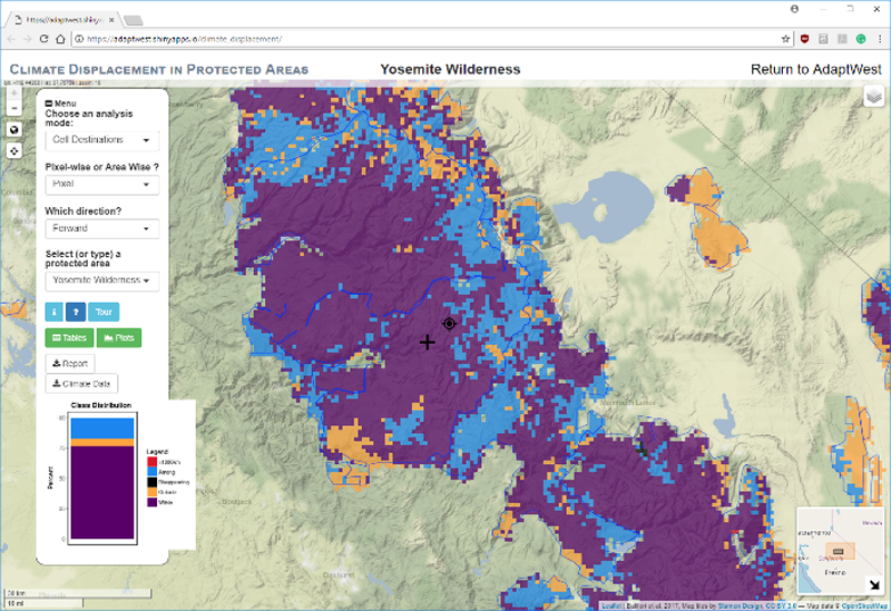 Figure 2. Screenshot of application showing forward migration target location (black bulls-eye) for a pixel within Nahanni National Park Reserve of Canada (black +). This analysis can be done for any pixel in any protected area, or for all pixels at once. |
This application was developed with participation by researchers from the following organizations: Center for Ecological Research and Forestry Applications, AdaptWest, Canadian Forest Service, Parks Canada, University of Alberta, Aldo Leopold Wilderness Research Institute (USDA Forest Service), and University of California Santa Barbara.